The Internet of Things (IoT) has wide applications in Disaster management and hazard management. For example, Forest Fire detection systems, IoT based systems to control coronavirus. And in the detection of Earthquakes, Cloudbursts, and Volcanic activities.
Landslides are nothing but a mass movement of rock, soil, or debris, down a slope. According to The Hindu, Landslides are the third biggest natural disaster worldwide. About 15% of India’s land is prone to landslides. And India has the highest number of landslide deaths in the world. So, there is a necessity to have an IoT based early landslide detection and warning system.
IMPACT OF LANDSLIDES
According to WHO, an estimated 4.8 million people got affected due to landslides from 1998 – 2017. Landslides cause huge damage to life and property.
- Restrict human movement on Highway and Railway lines.
- Damage houses, roads and pose damage to public infrastructure.
- Can result in permanent landscape changes. Due to soil erosion and loss of cultivation land.
- Soil and mudflow from land slopes finally land up in River water. Resulting in water pollution.
WHAT IS IOT ?
The Internet of Things (IoT) is a group of technologies that connects physical things to a network. By virtue of which we can communicate with Physical things. Thing in IoT can be sensors, cameras, valves, alarms or anything like them. These things communicate with each other using a communication protocol.
They may use the cloud to analyze the data and activate the actuator system. Also machines can directly communicate and analyze data with each other without using the cloud.
IoT Architecture uses embedded systems, such as processors, sensors, and communication hardware. For example, IoT enables gas leakage detection in the kitchen. Sending automatic SOS alarms to the user and firefighter. Also, in case of fire, it can activate the sprinkler system.
HOW DOES IOT BASED EARLY LANDSLIDE DETECTION SYSTEM WORK?
IoT based Landslide detection system uses Sensors, Gateway, Cloud, and Mobile or Web application. Landslides are dynamic phenomena; they depend on various environmental variables. Landslides depend on Rainfall, Soil moisture, Pore pressure, movement, and Vibration
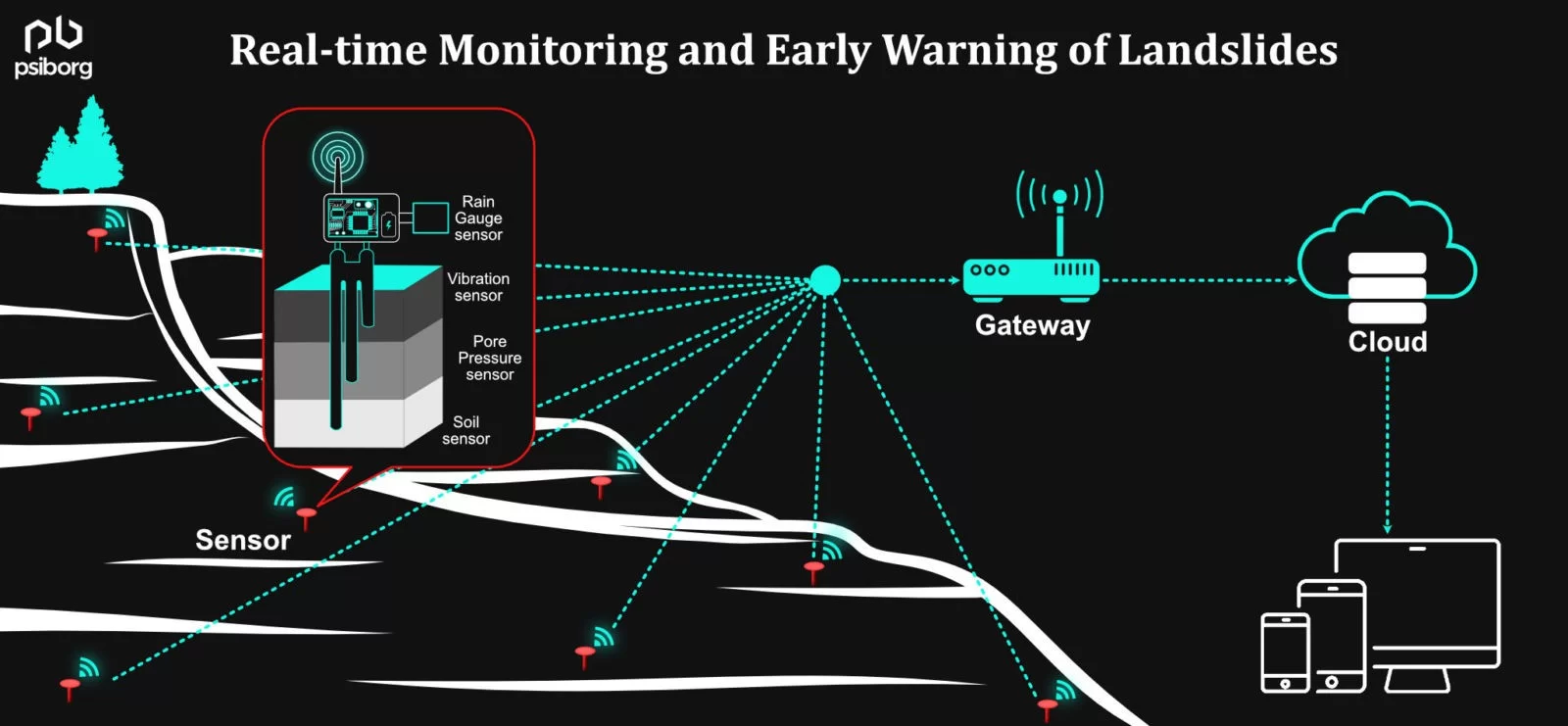
IoT hardware uses sensors like soil moisture sensor, rain gauge, Pore pressure sensor and vibration sensors. Sensors detect the environmental variables of the landslide prone area. All Sensors are installed in specific patterns at different soil layers collectively called Deep Earth Probe (DEP). This works as a Sensor Node.
Every Wireless Sensor Node (WSN) transfers data to the gateway. DEP is either powered by solar energy or battery. Landslides occur on slopes and triggering parameters vary at different regions of the mountains. So, DEP is placed in different mountain regions like crown, middle and toe. Also, DEPs are installed at different depths. All DEPs are programmed separately, according to the terrain and region.
Data is characterized and analyzed in the Cloud, based on Machine learning algorithms. The possible landslide alert and real time monitoring data of environmental variables can be seen in mobile applications. The IoT based Landslide detection system is able to predict possible landslides.
DIFFERENT LANDSLIDE ZONES IN INDIA
Landslides can occur in a wide range of geographical areas. In mountainous and hilly areas, it is in the form of rockfall and mudflows. In Slopes and Riverbeds areas, it is in the form of debris flow. Landslides are prone in coastal areas and underwater structures due to continuous tides.
List of Landslide Hazard zones in India as classified by National Disaster Management Authority (NDMA) :
- Very high Hazards: These areas are prone to earthquakes and receive heavy rainfall. These areas in India include the Greater himalayan range. In states of J&K, Himachal Pradesh, Uttarakhand, and parts of north eastern states.
- High hazard: These areas include Himalayan region between Greater Himalaya and Shivalik range. Himalayan states mostly come under high hazard zones.
- Moderate hazard: Trans himalayan areas of ladakh and Spiti valley of himachal pradesh. Mountains in Meghalaya, Aravali mountains, Rain shadow areas of western and eastern ghats. Mines, due to blasts, come under moderate hazard zones.
- Low Hazard: It includes the remaining parts of the country. Which are safe from landslides.
SENSORS USED FOR EARLY LANDSLIDE DETECTION
- Soil moisture sensor: It measures the moisture content of soil.
- Rain gauges: It measures the amount of rainfall an area receives in a particular time.
- Pore pressure sensor: It is a type of piezometer. It measures pressure of groundwater held within a Soil / Rock.
- Vibration sensor: It is a type of accelerometer that senses vibrations. It measures the Earth shaking effect.
SENSOR NETWORK SYSTEM FOR REAL-TIME MONITORING AND EARLY WARNING SYSTEM FOR LANDSLIDES DETECTION
Landslides can be detected using Remote sensing techniques. Landslide detection based on Internet of Things (IoT) and Wireless Sensor Networks (WSN) offers real time detection, with accuracy and without any human error. Also, WSN captures significant IoT data of the geomorphology of landslide prone areas. Thi data can be monitored remotely.
WSN is an emerging, reliable, and inexpensive technology, which offers real-time monitoring over long distances and inhospitable terrains. IoT and WSN use sophisticated communication protocols and analyze complex sensor data. It can not only detect landslides but can also predict them.
All this information is accessible to the authorities concerned through the Mobile / Web Application. Concerned authorities like Government agencies, Rescue and rehabilitation teams and Disaster management teams can access all the earth’s environmental variables on a real time basis. Even local people can also get landslide alerts on their mobile through this system. Government agencies can also share Rescue plans with landslide affected peoples.
IoT based early landslide detection and monitoring systems provide a complete communication channel. That is to say, from detection to rescuing people, the IoT communication protocol can integrate all these services.
CONVENTIONAL LANDSLIDE MONITORING TECHNIQUES
Physical inspection requires large teams of Geologists. To visit the area and carry out topographic surveys. Using Strain gauge, Rain gauge, Inclinometer, Pore pressure piezometer etc.
Remote sensing concerns satellite-based observation.
Both the techniques are inefficient as they are not able to detect and predict landslides. Physical inspection only tells us about possible regions of landslides. Traditional methods are also unable to detect and monitor landslides on a real time basis. Even if we install some sensors to detect landslides. And since a landslide does not only depend on any one variable. So, these methods are prone to trigger false alarms.
BENEFITS OF USING IOT BASED LANDSLIDE DETECTION AND WARNING SYSTEM
IoT architecture uses various advanced technologies. Like LoRa based wireless sensor network and M2M communication protocol. IoT coupled with Artificial intelligence and Machine learning algorithms. Allows us to build smart solutions for landslide management.
LARGE SCALE DEPLOYMENT OF SENSORS
Embedded sensor devices installed in the hazardous region. Embedded sensor devices contain various sensors. And a communication protocol. Embedded devices are placed in the LoRa based wireless sensor network communication protocol. It allows hundreds of sensors to connect to a network. This system is energy efficient and fault proof.
Suggested Reading: Embedded Hardware Designing
REAL TIME DATA MONITORING
The sensors transmit data to a central gateway, And from there to Cloud. Cloud server performs the data analysis. Data Analysis is based on machine learning algorithms. The information from the cloud is then sent to concerned parties in the IoT dashboard. On Mobile and Web applications. The information shown is user specific and on a real time basis.
INTELLIGENT DATA PROCESSING AND ANALYSIS
Machine learning enables us to read data intelligently. An accurate model depends on various variables. Landslide detection systems depend on many environmental variables. For example, soil moisture, pore pressure and vibration. from various sensors like Rain gauge. And if an alert is generated based on any one parameter. Then it is often a False alert, in case of landslides. But if we use a Machine learning model. Then an alert is generated based on various variables. And this intelligent system learns continuously from the data.
SERVING MANY STAKEHOLDERS
Various Stakeholders can be Government agencies, Local people and Rescue and Rehabilitation teams. Government agencies will receive data on a real time basis. Using this data, government agencies can prepare on time and better rescue plans. Local people through Mobile / Web applications can see real time hazards.
DIFFERENT LANDSLIDE ZONES IN INDIA
Landslides can occur in a wide range of geographical areas. In mountainous and hilly areas, it is in the form of rockfall and mudflows. In Slopes and Riverbeds areas, it is in the form of debris flow. Landslides are prone in coastal areas and underwater structures due to continuous tides.
List of Landslide Hazard zones in India as classified by National Disaster Management Authority (NDMA) :
- Very high Hazards: These areas are prone to earthquakes and receive heavy rainfall. These areas in India include the Greater himalayan range. In states of J&K, Himachal Pradesh, Uttarakhand, and parts of north eastern states.
- High hazard: These areas include Himalayan region between Greater Himalaya and Shivalik range. Himalayan states mostly come under high hazard zones.
- Moderate hazard: Trans himalayan areas of ladakh and Spiti valley of himachal pradesh. Mountains in Meghalaya, Aravali mountains, Rain shadow areas of western and eastern ghats. Mines, due to blasts, come under moderate hazard zones.
- Low Hazard: It includes the remaining parts of the country. Which are safe from landslides.
PsiBorg is an IoT product development company and an IoT consultant. We use state-of-the-art technology integration to provide a complete IoT based Landslide detection and monitoring system.
We specialize in full stack development of IoT solutions. Please go through how we develop an IoT solution.